The overall extents of the visual influence of the site are relatively well contained due to a combination of the nature of the topography, proximate settlement and scattered linear structural vegetative features, particularly to the north, east and south. Countesthorpe is also on slightly higher comparative ground relative the site.
Overall, the number of people (visual receptors) affected by the development of the Site would be limited and localised. In response to both desktop assessment and fieldwork, a series of landscape opportunities and constraints have been established to guide the sensitive development of the site. These observations have informed the Framework Plan and Subsequent Layout and represent a ‘landscape led approach’.
The key themes of the current strategy therefore include:
In summary, changes as a result of the development of the Site would affect only a limited geographical area, one within which the adjoining residential edge already exerts a notable urban influence. Furthermore, new soft landscaping incorporated into the development proposals would provide enhancements consistent with those observed within the wider LCA and ensure that the proposals are sympathetically integrated into the landscape.
Given the existing containment of the site in its local context together with the retention and enhancement of the existing site field boundary features and inclusion of the proposed landscape buffer, the development is considered to have very limited visibility. This is both in terms of scope and numbers of receptors, and geographical influence, which would be principally confined to the immediate and short distance.
The planning application will be accompanied by a Landscape Visual Assessment which will identify and assess the impacts of the development upon the surrounding landscape, and the visual appreciation of the landscape. This will include an assessment of key viewpoints, the specific contribution of the local landscape, and the impacts of the development upon it.
An archaeology and built heritage assessment has been carried out for this site, including consultation with the Leicestershire Historic Environment Record (HER) and Record Office. This confirms that the site has low archaeological potential.
The closest designated heritage assets to the site are a group of late 19th century houses (No.1-7 The Drive) and associated structure, which are a well-preserved example of early social housing provision. The houses are more than 100m away from the site and have no relationship to the site. As such, the development is not considered to harm their significance.
A Preliminary Ecological Appraisal (PEA) has been undertaken to assess the potential ecological constraints of the proposed scheme and make initial recommendations for incorporation into the masterplan development. This initial work has informed the proposals presented thus far, and has also identified any further ecological surveys and mitigation measures that would likely be required to secure a planning permission. The scheme will incorporate a range of mitigation measures as required to ensure minimum ecological impacts.
Additionally, a Biodiversity Impact Assessment (BIA) is to be undertaken to assess the scheme’s potential to achieve a biodiversity net gain. Once further survey work is completed and the masterplan finalised, an Ecological Impact Assessment (EcIA) will be submitted.
The current Environment Agency indicative flood mapping illustrates that the application site is located within Flood Zone 1. It can therefore be considered to be at the lowest probability of fluvial flooding (<1%).
The Environment Agency surface water mapping suggests that the site is at a very low risk of surface water flooding, whilst there is a localised area to the west of the site that may be susceptible to a low level of over land surface water flow, which is consistent with the lower lying topography in this area.
Based on the information available, including that from the Environment Agency and within the local authority’s Strategic Flood Risk Assessment, the site is not considered to be at risk of flooding from groundwater, drainage, or artificial sources such as reservoirs.
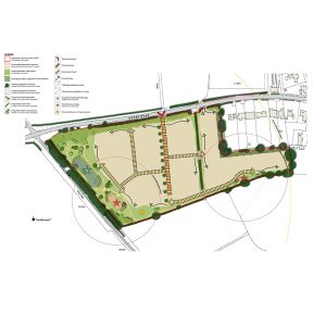
The low level of overland surface water identified on the Environment Agency mapping will be mitigated within the development by directing flows away from dwellings and towards the extensive landscaping proposed along the western boundary, which will include an open SuDS feature in the form of an attenuation pond. This will contain an appropriate freeboard depth above the storage volume required for the surface water run-off from the development, which will accommodate overland exceedance flows.
Subject to confirmation of available capacity from Severn Trent Water in accordance with the Water Industry Act 1991, it is proposed to connect foul drainage from the proposed development to the public sewer network situated to the east of the site. On the basis that sufficient capacity is available, or appropriate off site mitigation measures are carried out as necessary, there will be no increase in flood risk to other areas from this source.
Due to the topography of the site, a foul pumped outfall from the development to the public sewer network will be required.
The developments main surface and foul water drainage networks will be promoted for adoption in accordance with the Water Industry Act 1991.
The proposed development would facilitate foot and cycle movements along desire lines through the development, linking to the external access points and footway infrastructure. This will include the provision of the following where appropriate in line with Manual for Streets and Manual for Streets 2:
Connection between the site and the centre of Countesthorpe to the east is achieved via lit footways located along both sides of Cosby Road which currently terminate a short distance to the east of the site.
As part of the site access strategy, it is proposed that a new section of lit footway would be provided between the site and existing footway to the east.
It is proposed that a new vehicle access will be created onto Cosby Road in accordance with the Leicestershire Highways Design Guide and Manual for Streets. This would take the form of a priority T-junction, with a 5.5m wide access road created and appropriate visibility splays would be provided.